The North of England offers a staggering treasure trove for lovers of the great outdoors. I now understand why the roads are clogged with caravans, every small town's high street has a hiking store, so many cars sport bike racks and the world-famous "Tour de France" expanded its venue to Yorkshire. There are deep, green valleys bisected with picture-perfect rivers. Vast moors covered with heather that, in its August bloom, looks like the heavens have been raining light purple paint. Long beaches of powdery sand, bordered by an ecosystem of dunes covered with grasses flowing like an inland sea.

The vistas are wide, the roads quiet and the crowds ... at least in this year of Covid-19 ... minimal. My usual holiday is a cultural one, as this blog attests. But if you wanted to do a holiday that was purely about hiking, swimming and cycling, you could pack two weeks here with highly varied activities. Or just unpack a lawn chair, sit next to your car in a picturesque lay-by and drink in the view.
Our wanderings didn’t even include the world-famous Lake District, on the Western edge of the region we explored. Here are the most beautiful natural sites we encountered. Not particularly fit? Neither are we. Though all of these areas are ideal for hikers, we consumed an impressive amount through easy drives or short, gentle walks.
The Yorkshire Dales
When you see idealised visions of the English countryside, they’re probably either set in the Cotswolds, or the Yorkshire Dales. The two are similar, but everything is bigger in the dales. Valleys are deeper. Rivers broader. Hills higher. Sheep and cows wander in greater profusion. The area makes you understand why people from Yorkshire pronounce their home county to be “God’s Country” with such knowing confidence.

You can easily do a whole holiday in the Dales, especially if you’re keen on hiking, but it’s also possible to do a satisfying circle tour in a day that gives you a range of sights and isn’t particularly challenging driving. Though the roads do get narrow in places and you might lose some time caught behind farmers moving their cows between fields.

Our 120-mile round trip from Harrogate took the B6265 through Hebden, Then turned North through Kettlewell to Aysgarth, then West to Hawes before turning South to Ingleton, where ... sated with magnificent landscapes ... you join the A65 and zip back to Harrogate on major roads. It’s a 3.5 hour drive without stopping but you will, of course, pull over for countless photos and dawdle at various tourist attractions.
Along the way you’ll find high moors, both spectacular and desolate, with views that go on for miles. In between them are deep valleys, sometimes wooded and sometimes full of lush green fields, each characterised by the gentle rivers that wind through them. In some places there are spectacular rock formations, showing the massive power of ancient glaciers. Other bits are more distinctively shaped by man, with miles of stone walls segmenting the fields. There’s a famous waterfall at Aysgarth that descends in broad plateaus and is gentle enough for people to wade in. On the hot, sunny day of our drive, people had packed that site and were bathing anywhere the landscape allowed easy access to the crystal-clear rivers.

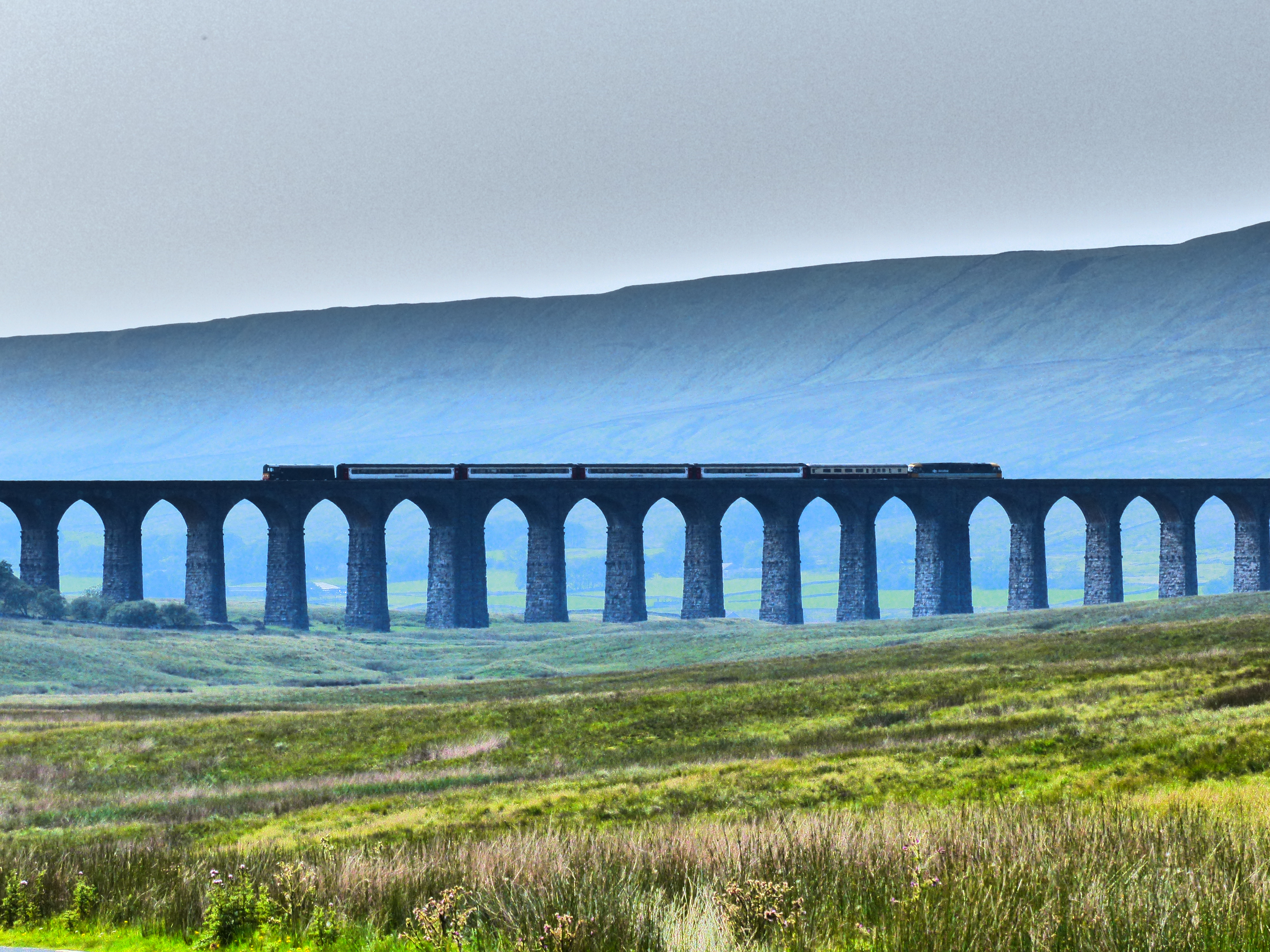
Hawes is the logical half-way point on the drive, a tourist town packed with pubs and small independent shops. It’s also home to the Wensleydale Creamery, largest producer of the area’s famous cheeses and well worth a stop. (Under normal circumstances there’s a factory tour, currently shut down by Covid-19. The restaurant and shop, with cheese and Yorkshire-themed gift items, were doing a roaring trade.) The star site on the way back to the A65 is the Ribblesdale Viaduct, a bold Victorian architectural statement stretching across a particularly vast and wild moorland landscape.
The North York Moors
Any English person will tell you the reason we all head to the airport for our holidays is the weather. If you could guarantee sun, we’d never leave. But few people want to take the gamble. Our day on the North York Moors was a case in point. I can tell you that Hutton-le-Hole is a ridiculously charming village of matching grey stone buildings with red tile roofs that cascades down a hill on either side of a village green where stepped banks lead to a small, swiftly-flowing stream. The Crown, near the top of town, is the kind of cosy, well-appointed country pub we all fantasise about having as our local, complete with hearty ploughman’s lunches and bowls of clear water for your dogs. And I can assure you that it all looks fabulously romantic even with threatening skies and swirling mists.
After that, however, my entire impression of this famous National Park is of a ribbon of tarmac, a strip of heather on either side of the car and the occasional sheep too close for comfort in the roughly 10 feet of visibility we had for our entire journey across the moors. A few times we descended into villages, where the fog cleared a bit and we could make out the profiles of farmhouses and fields tucked in protective greenbelts below the high moors. But for more that that, I have to rely on other people’s photos. If you’d actually been staying in the National Park, you wouldn’t have wanted to set foot outside your front door. In fact, travel very far on foot would probably have been dangerous as you would inevitably loose your way.
This was a bitter disappointment, as the landscape is legendary and its famous heather was in bloom. But weather in Britain is a bit like strikes in Italy; best not to expect 100% tourism success and have Plan B ready for when circumstances get in the way. On this day, for us, the disappointment also included Robin Hood’s Bay, a picturesque run of cliffs and beaches just south of Whitby. Though we drove as far as Whitby (underwhelming), it was pointless to seek out more views with such limited visibility. The alternative was arriving at our hotel early. In a future story I’ll write about Lumley Castle and you’ll see that was no great sacrifice.
Hadrian’s Wall
Yes, this is a cultural site, with museums, ruins and lots to learn along its route, but exploring this World Heritage Site is also a blockbuster landscape experience. The Romans chose a natural ridge in rolling border country. Sometimes it’s no more than a gentle hill, but others it’s a towering escarpment, as if the land had formed itself into a wave to crash down into the lands to the North. The wall runs 73 miles from the banks of the Tyne to Solway Firth, and keen walkers can follow the whole thing on a clearly-signposted path. It’s harder to follow by car.
Though the B6318 follows most of it, the road meanders and the ruins often disappear into farm fields. It’s a beautiful drive, and it does occasionally run right next to the wall and various mile posts (guard towers), most standing no more than a few feet above the ground.

But you won’t get much sense of the scale of the thing without a bit of a hike.
The most dramatic place to take it all in is probably at Housesteads Fort, one of the biggest excavated areas along the wall. (Managed between English Heritage and the National Trust, and free to members of either.) Be ready to use your imagination; this is not the Great Wall of China. Hadrian’s Wall has been a convenient source of dressed stone for locals for centuries, so there’s not a great deal left. What you get at Housesteads is the excavated foundations of a full army camp stretching right up to the wall, and a clear view of the wall running in either direction, in particularly dramatic landscape. This is one of those places where the wall took advantage of a high, natural escarpment to dominate all around. There’s a valley on both sides, so it’s a hike down and up again to reach the site from the car park. But it’s worth the effort both for the ruins and the views. From there you can have a fairly gentle stroll for at least a mile in either direction before you have to conquer any more inclines, all the while taking in expansive views.

This might have technically been the end of civilisation, but on a sunny day, looking out on mile after mile of green, gentle, rolling farmland, with a proper Roman baths complex to soak away your worries at the end of the day, this can’t have been too bad a posting.
The Northumbrian Coast
If they bordered warm waters rather than the North Sea, Northumbria’s beaches would regularly grace the covers of luxury travel magazines. They are, quite simply, spectacular. The sand is golden and fine, and beaches stretch for uninterrupted miles with nothing but grassy dunes or farm fields behind them. It’s no surprise that they reminded me of the glorious and equally empty beaches around Skagen, Denmark, since that’s what’s on the other side of the water. Even when civilisation intrudes, it’s a picturesque fishing village, a handful of stone holiday cottages or a dramatic castle rather than high-rises or urban spaces.

You’re at the mercy of the weather, of course. Over five days in Northumbria we experienced one of impenetrable fog and steady drizzle, two with glowering grey skies and intermittent downpours, and two of idyllic perfection, with temperatures in the mid 20s (low 70sF), blazing sun, gentle breezes and white marshmallow clouds giving depth to vivid azure skies.
On the best of those days we spent a morning on Alnmouth beach, so enormous that even with a full car park (be prepared to pay the princely sum of £3 to park for the day), people simply disappear along its length. As you might guess from its name, this is the village where the river Aln meets the sea, several miles East of the larger Alnwick and its castle. By the time the river enters the beach it’s abandoned most of its force in water meadows behind the village, leaving only a shallow stream of bright, pure water to meander across perhaps 200 metres of sand before merging with the sea. (The extraordinary breadth of the sand here reminds me of the more famous Holkham Beach in Norfolk.) A dune-covered headland juts out to the North, but to the South you can see ... and walk ... for miles on beaches that are generally empty of other humans once you get a few hundred yards past the car park. The water here is shallow quite a ways into the surf, making it ideal for wading and giving it a chance to warm up to something a little less numbing when the sun is at full strength.

Equally fine was St. Aidans beach (first photo in this section, and below), in between the fishing village of Seahouses and the majestic Bamburgh Castle. There’s no official car park here, therefore even fewer people. Watch out for a National Trust sign next to a group of coastal cottages, with free parking on the grass beside the road. A narrow path next to the cottages leads down to a glorious beach where you’ll often find yourself alone for many minutes before another walker passes. Off shore you can see the outline of the Farne Islands, famous for bird watching, and you’ll hear the buzz of tourist boats going to and fro, but that will be the only sign of human habitation on much of this stretch.

Alnwick Moors
We might have missed the North York moors behind their screen of fog, but we got Alnwick’s version instead. The B6341 between Alnwick and Cragside cuts in an easy-to-drive straight line through heather-covered moor and long views. There’s the occasional sight like the rock escarpment at Corby Crag or the ruins of the castle at Edlingham, but it’s mostly just miles of hauntingly-barren heather. Barren, that is, except in late august, when the moors come into bloom and the entire landscape turns an otherworldly pinky-purple.

The moorland landscape is interrupted by the estate at Cragside, where builder Lord Armstrong claimed that he planted over seven million trees. Even if he overstated, there’s no denying that he completely transformed the landscape, creating an ecosystem closer to the foothills of the Alps in the middle of these moors. The Alpine landscape was meant as a suitable setting for his Victorian pastiche castle, often called England’s Neuschwanstein. The house is currently closed thanks to the pandemic, but I suspect most locals come here for the landscape.
There are more than 40 miles of marked hikes through the forests, many of them with spectacular views of Armstrong’s house, the lakes he built to provide hydro-electric power to run it (in the late 19th c; it was the first house in the world use hydroelectric energy), or the dramatic crags, burns and moorland views that preceded him. Not up for hiking? There’s a 7-mile “carriage ride” with frequent lay bys to pull over and appreciate the view. The heather made Cragside glorious in August, but the number of Rhododendron and azalea planted throughout the estate suggest May and June must be brilliant, too.

No comments:
Post a Comment